Implementation phases of GISSOM
Phase 0: GISSOM Set up
LTM’s proprietary GISSOM product was set up on Azure for preventive maintenance (surveys) and asset management.
Phase 1: Deployment and enhancements
Phase 1 application builds were deployed to districts south eastern district (SED), gulf coast district (GCD), and north east district (NED), covering all pipeline stretch assets. Bulk survey reading data imports were enabled via the GISSOM web application at flexible intervals. Atmospheric facilities were added as a new asset category, with parent-child relationships established between entities like facilities-assets and tanks-test points.
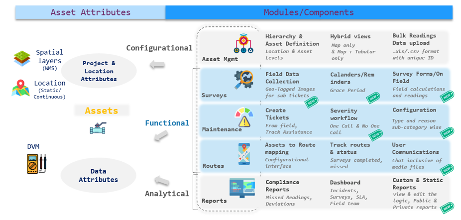
A calendar view streamlined survey scheduling, linking specific survey types (e.g., Rectifier PM, Inspections) to assets with distinct schedules. An automation workflow created tickets for high-priority issues, allowing manager comments and enabling self-assignment. Automated workflows for ticket management (assigning, resolving, escalating, and closing) and survey email notifications were also established.
Phase 2: Streamlined workflow enhancements with upgrades
We introduced several updates to optimize asset and maintenance management. Users could view and edit logic for static reports across surveys, maintenance, assets, and field engineers. Maintenance types and reasons were customizable by sub-category, and an atmospheric facilities maintenance workflow was implemented. Survey workflows accounted for a grace period on overdue dates, and new survey types were supported on the web application. Geo-tagged images could be captured during maintenance sub-ticket resolutions via mobile, with sub-tickets manageable on both web and mobile platforms.
A chat module facilitated communication between managers, admins, and field technicians, supporting file attachments, replacements, and file history viewing. Public and private report templates were introduced, allowing district-wide access for public reports and private ownership for individual users. Maintenance severity workflows included urgency attributes, ensuring more targeted prioritization.
Phase 3: Comprehensive system upgrades and new workflows
This phase involved integrating existing geospatial information system (GIS) datasets and migrating historic pipeline compliance system (PCS) data to create a robust data foundation. The ticketing system was upgraded to support the main and sub-tickets for Atmospheric facilities outside of surveys. An ask engine data directory was introduced, enabling users to query, analyze, and access actionable insights from relevant datasets.
Reporting was enhanced with tools to track data progression, improved custom report modules with search functionality, and overlay features to consolidate survey data, uncover trends, and highlight recurring issues